Toll Free + 1 (800) 245-7660
27 January 2020
The power of real-time traffic data
Mexico City is one of the most populated metropolises in the world. The bustling capital and economic center of the country is home to more than 21 million inhabitants, and it is a city that has it all: culture, food, entertainment, sports and, of course, lots of traffic. According to the National Institute of Statistics and Geography (INEGI), a government agency providing statistical information in Mexico, the city had more than 5.8 million registered motor vehicles in 2018.
Mexico city: an important traffic congestion
In another report from 2018 by TomTom, Mexico City was ranked as the city with the worst traffic congestion level in North America and ninth worldwide. If you have ever been to Mexico City, you will have experience how bad traffic can be. It’s not uncommon to see street vendors walking through congested areas selling anything from snacks to phone cards. To make matters worse, Mexico City suffers a huge air pollution problem due to its geographic location and the volume of motor vehicles.
Inhabitants have adapted their way of life and they plan their days according to traffic. For example, a journey that would usually take 20 minutes might last more than two hours during rush hour. In 2013 the Costa Rican national soccer team got stuck in traffic and arrived 55 minutes late for a World Cup qualifier match, delaying the start of the game. Traffic accidents, construction, protests and special events are all commonplace. They all cost time and time is money.
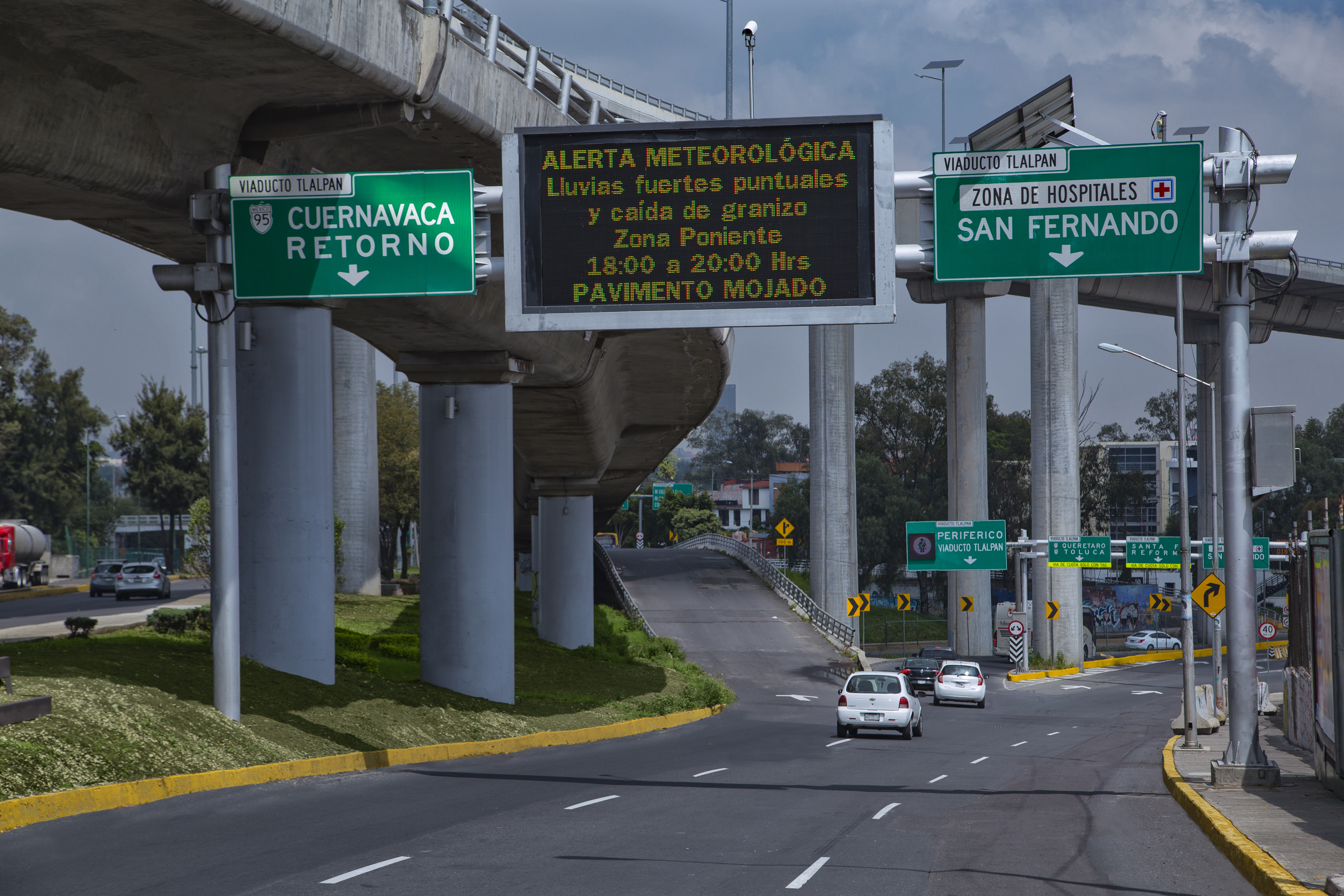
A new solution: Infovial
They also worsen the city’s air pollution problem. How does it overcome these unexpected traffic conditions? The city believes the answer is in realtime traffic data. The Secretaría de Obras y Servicios del Gobierno de la Ciudad de México (Public Works Ministry) implemented a real-time highway information system in 2009 called INFOVIAL. The system was developed by Signal Group and provides the agency with real-time traffic conditions for 350km of major roads in Mexico City, allowing the agency to react in a more timely and efficient manner when unexpected traffic conditions occur.
INFOVIAL consists of a web-based traffic management software system integrating more than 340 traffic data sensors plus 70 variable message signs (VMS) which communicate via a 4G cellular network. The system collects real-time data of traffic conditions such as speed, volume, occupancy, classification of vehicles and traffic incidents, and displays it all on a map at the Traffic Management Center (TMC), where conditions are monitored 24/7. TMC operators can then apply different strategies based on the current conditions and provide the driving public with alternate routes and information via the 70 VMS signs which are installed across the network.
Besides providing real-time data, INFOVIAL stores the data collected from the sensors and offers the agency historical information which allows the agency to create traffic studies for the development of future efficient traffic strategies.
Great benefits for everyone
Since its implementation, INFOVIAL has provided the Public Works Ministry with the following benefits:
- Providing an accessible and reliable database of traffic conditions from major roads in Mexico City.
- Allowing the agency to develop research programs and mobility studies such as volume, service levels, occupancy, average speeds, traffic trends and air quality.
- Analysis and evaluation of highway traffic conditions, which can then provide an overview of traffic behavior.
- Identifying solutions that can help reduce traffic congestion such as the implementation of reversible lanes, updated signal timings, speed limits and more.
- A source of information for traffic modeling, allowing the agency to maximize the capacity of the existing highway infrastructure.
- Allowing understanding of the impact in traffic conditions due to new infrastructure construction throughout the city.
- Informing drivers in advance about unexpected traffic conditions such as public events, traffic incidents, temporary road closures and environmental conditions, and offering alternate routes.
INFOVIAL’s success is due to the proper interest in and planning for better mobility at the Public Works Ministry in combination with the software development and technology integration achieved by Signal Group.
Ultimately, it’s the result of Signal Group’s commitment to the development of intelligent solutions for better mobility and traffic safety around the world.

Gustavo de la Peña VP Sales
Subscribe to our Newsletter
Get information about our latest innovations, upcoming events and industry news.

